Built for agricultural operations

Hyperlocal Weather and Soil Intelligence for Agriculture

Measure the conditions your crop actually experiences, not conditions recorded 40 km away. Real time rainfall, soil moisture, wind, and temperature to support irrigation, crop protection, and climate risk decisions.

★★★★★ Trusted by 100+ customers
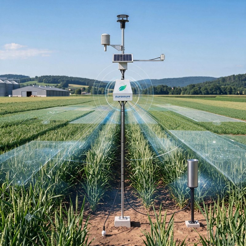
Aurassure automatic weather station deployed for agricultural weather and soil monitoring Hyperlocal weather monitoring station measuring rainfall, wind and soil conditions
Live site intelligence Live field level conditions
Capacite logo
Chemtrols Industries Private Limited logo
Chintels India Pvt Ltd logo
D.E.C Infrastructure And Projects India Pvt Ltd logo
Emaar India logo
Group logo
Himalayan Infracorp Private Limited logo
Indigo Infraprojects Pvt Ltd logo
KPC Projects Limited logo
Client logo
LTI Mindtree logo
MNB Build Fab Private Limited logo
Northwind Estates Private Limited logo
Signature Global logo
Tarc Projects Limited logo
Capacite logo
Chemtrols Industries Private Limited logo
Chintels India Pvt Ltd logo
D.E.C Infrastructure And Projects India Pvt Ltd logo
Emaar India logo
Group logo
Himalayan Infracorp Private Limited logo
Indigo Infraprojects Pvt Ltd logo
KPC Projects Limited logo
Client logo
LTI Mindtree logo
MNB Build Fab Private Limited logo
Northwind Estates Private Limited logo
Signature Global logo
Tarc Projects Limited logo

Get in Touch with Aurassure

Aurassure AWS in Agriculture field tracking realtime environmental parameters
Agriculture Reality

Growing Conditions Change Field by Field, Season by Season

Rainfall, wind, heat, and soil moisture can vary sharply within a few kilometres. Without field level measurement, decisions rest on conditions that were never recorded where the crop is growing.

Weather and soil monitoring station installed in an agricultural field
Field conditions Variable and hyperlocal
Rainfall variability
Soil moisture uncertainty
Unseasonal events
Why this matters
3.2M ha

Crop area affected by extreme weather in India in a single year.

Much of that exposure is avoidable. Teams need earlier awareness of rainfall, heat, wind, and soil conditions to time irrigation, protect crops, and reduce preventable loss.

Centre for Science and Environment, Climate India 2024
01

Hyperlocal variability

Rainfall, wind, and temperature can differ sharply between neighbouring blocks.

02

Timing critical decisions

Irrigation, spraying, harvest, and drainage all depend on acting at the right moment.

03

Rising climate volatility

Unseasonal rain, heat, and dry spells are now recurring rather than exceptional.

Without Field Level Monitoring

What Happens When Field Conditions Are Not Measured

When conditions are not measured where the crop is growing, decisions fall back on regional averages and habit. Water is applied at the wrong time, inputs are wasted, and preventable losses often become visible only after the season.

01

Water and Energy Wasted

Irrigation scheduled by calendar rather than by soil condition applies water the crop does not need, raising pumping cost and increasing waterlogging and leaching.

02

Inputs Lost to Poor Timing

Sprays applied into rising wind, high heat, or ahead of unexpected rain drift, evaporate, or wash off, and then have to be repeated at full cost.

03

Avoidable Loss During Extreme Events

Harvested produce, standing crop, structures, and equipment stay exposed because the warning was regional and arrived too late to act on locally.

04

No Record That Stands Up

Without continuous local data, claims, audits, and planning decisions rest on conditions reconstructed after the event rather than measured as it happened.

Environmental risk in agriculture does not stay in one place. It compounds across water cost, input cost, yield, and the ability to prove what actually happened.
Core Requirements

What Agricultural Operations Actually Need

Managing weather and water risk in agriculture requires more than a forecast. It requires measurement at the field itself, a clear reading of what those conditions mean for the crop, and the ability to act while there is still time to act.

Soil moisture and weather monitoring installed in an agricultural field
01

Measure Conditions at the Field

Track rainfall, temperature, humidity, wind speed and direction, solar radiation, soil moisture, and soil temperature where the crop is actually growing.

02

Understand Water and Crop Stress

Read root zone moisture alongside rainfall received and the heat, humidity, wind, and solar conditions that drive how fast the crop loses water.

03

Act While It Still Matters

Set thresholds for wind, rainfall, heat, and soil moisture so the right person is alerted before an irrigation, spray, or harvest window closes.

04

Keep a Record That Holds Up

Maintain continuous, timestamped, exportable environmental data across seasons, blocks, and sites for claims, audits, planning, and research.

The Solution

Aurassure AWS for Field Level Agricultural Intelligence

Aurassure AWS measures weather and soil conditions directly at the field and sends them to a connected platform, so teams can see what is happening across their blocks, compare conditions, and act while the decision still matters.

01

Built for real field conditions

Outdoor deployment with AC, DC, or solar power and battery backup, multiple connectivity options, and onboard storage so a network gap does not become a data gap.

02

Weather and soil in one station

Soil moisture and soil temperature measured alongside rainfall, wind, temperature, humidity, and solar radiation. Standard on AWS Pro and AWS Expert.

03

Turns measurement into timing

Configurable thresholds and alerts for wind, rainfall, heat, and soil conditions, so irrigation, spraying, and harvest decisions are made on current readings.

Aurassure Automatic Weather Station for agricultural weather and soil monitoring
Connectivity 4G LTE, WiFi, RS485
Power AC, DC, or solar
Reporting 1 min, down to 15 sec
Alerts SMS and email
See the full AWS page for model comparison and specifications
Aurassure AWS Range

Choose the Right Station for Your Operation

A single farm, a plantation group, and a state wide observation network do not need the same station. Compare the differences that matter most for agriculture, then explore the full technical specifications.

Essential Monitoring

AWS Lite

Core hyperlocal weather visibility for farms and supplementary sites where continuous local conditions are the main requirement.

Wind Mechanical, 0 to 50 m/s
Rainfall General monitoring
Radiation UV and light intensity
Soil Configured extension
Typical fit Secondary blocks, cluster and FPO sites, general farm monitoring
Professional Monitoring

AWS Expert

The strongest standards oriented configuration in the range, with higher accuracy wind and professional irradiance measurement.

Wind Ultrasonic, 0.1 to 80 m/s
Rainfall Professional, to 240 mm/h
Radiation Class A GHI or GTI
Soil Moisture and temperature, standard
Typical fit Research institutions, agriculture departments, reference and network stations
Dashboard and Intelligence

Unified Visibility Across Every Field, Block and Site

The Aurassure platform brings live weather, rainfall, soil, and water data into one connected view, helping teams compare conditions across blocks, spot developing risk, and keep a continuous record across every season.

01

Live Monitoring

Track rainfall, wind, temperature, humidity, solar radiation, and soil conditions in real time through one connected interface.

02

Multi Block and Multi Site View

Compare conditions across blocks, farms, estates, or districts from a single dashboard instead of checking each location separately.

03

Role Based Access

Give farm managers, agronomists, water teams, and management the level of visibility each function actually needs.

04

Records and Reporting

Maintain historical trends and exportable records across seasons, and integrate the data into existing systems where required.

Mobile dashboard for farm weather and soil monitoring

Mobile Access

Check live field conditions, trends, and station status from anywhere, including from the field itself.

Threshold based weather and soil alerts for farm teams

Threshold Alerts

Set limits for wind, rainfall, heat, and soil moisture so the right people are notified by SMS and email before a window closes.

Multi site visibility across farms and estates

Multi Site Visibility

View every connected station through one platform to compare conditions, prioritise action, and maintain oversight across locations.

From Monitoring to Action

Turn Field Conditions Into Operational Decisions

Measurement earns its value when it changes what gets done, and when. Continuous field data helps teams read conditions sooner, act inside the window that matters, and build a record they can rely on next season.

01

Measure Continuously

Track rainfall, wind, temperature, humidity, solar radiation, and soil conditions at the field, minute by minute.

02

Read the Condition

See how soil moisture is trending, how much rain actually fell, and when wind or heat crosses the limits you have set.

03

Trigger the Decision

Route alerts to irrigation, spray, harvest, and drainage teams so action happens while the window is still open.

04

Keep the Record

Build season over season baselines that support planning, claims, audits, and long term crop risk decisions.

Field weather and soil data supporting irrigation and crop protection decisions
What this enables
Adjust irrigation timing and volume using soil moisture and rainfall
Identify suitable spray windows from wind, temperature, and humidity
Advance or pause harvest and drying ahead of rain and wind events
Prioritise drainage and pumping using rainfall and water level data
Maintain environmental records for claims, audits, and planning
In agriculture, the difference between a good season and a costly one is often a matter of days. Measurement at the field is what turns those days back into decisions.
Measurement Quality and Standards

Measurement You Can Defend

In agriculture, weather data does more than sit on a dashboard. It supports irrigation decisions, insurance claims, scheme reporting, and research. That means accuracy, siting, calibration, and maintenance matter just as much as the sensor specification.

Rainfall measurement
±2%
Rainfall accuracy at 120 mm/h on AWS Pro and AWS Expert

Professional grade precipitation measurement with a 200 mm collection orifice and 0.2 mm resolution, across a range of 0 to 240 mm/h. Rainfall is the parameter most often used to account for irrigation, assess dry spells, and settle weather index claims, so it is measured to a specification that supports those decisions.

Calibration and field verification of weather monitoring sensors
01. Standards Assessment

Assessed parameter by parameter

Aurassure publishes a component level comparison of each AWS configuration against WINDS, CEA, IMD, and WMO criteria, parameter by parameter, rather than a single blanket claim. AWS Expert is the strongest standards oriented configuration in the range.

02. Siting and Exposure

Positioned to represent the field

Sensor height, orientation, shielding, and distance from buildings, trees, heat sources, and reflective surfaces are planned during site assessment, so the readings represent the conditions the crop is actually experiencing.

03. Calibration and Lifecycle

Quality maintained across seasons

Measurement quality is not set once at installation. Calibration and verification schedules are defined around the selected parameters, the operating environment, and the requirements of the project, then maintained through the life of the deployment.

Inspection Calibration Alignment checks Preventive maintenance
Technical note: References to WMO, IMD, WINDS, or CEA apply at the relevant measurement and component level. They do not represent certification of the complete Automatic Weather Station. Final conformity also depends on sensor selection, calibration, shielding, mast height, exposure, data acquisition, field installation, and the issued project specification.
Insurance and Risk Intelligence

Hyperlocal Data for Crop Risk and Weather Index Insurance

Weather index insurance only works when the reference station is close enough to the insured field. As that distance grows, the index and the actual loss drift apart. Denser, well sited, well maintained stations are the most direct way to close that gap.

Brings the reference measurement closer to the insured field
Provides continuous, timestamped records for trigger monitoring and claim validation
Builds historical baselines for trigger design and portfolio level risk assessment
Hyperlocal weather station serving a cluster of agricultural plots for crop risk assessment
The basis risk problem Distance between field and reference station
Denser network
Closer reference
Lower basis risk
01
Why it matters
Weather based crop insurance settles against perils that can be measured and quantified at automatic weather stations and rain gauges. When the reference station sits far from the field, two failures follow: loss without payout, and payout without loss.
02
What Aurassure provides
Hyperlocal station networks with defined siting and calibration practice, continuous records with onboard storage so a network gap does not become a data gap, historical baselines, and integration into insurer and government systems.
03
What it supports
Trigger design and validation against denser observations, near real time monitoring through the season, evidence for claim validation, and cluster or district level climate risk intelligence.
Where our role ends. Aurassure provides the measurement and data layer. Index design, underwriting, pricing, and claim settlement remain with the insurer, reinsurer, or implementing authority.
Discuss Weather Data for Risk
Ecosystem Readiness

Built for How Agricultural Weather Data Is Used in India

Agricultural weather data no longer just informs advisories. It supports scheme reporting, insurance settlement, and departmental planning, which raises the bar on measurement, record keeping, and network reliability.

Assessed against referenced criteria:
WMO IMD WINDS / CEA Project specification
Assessment is carried out parameter by parameter and configuration by configuration. It is a technical reference, not accreditation or scheme empanelment.

What strong agricultural weather infrastructure looks like

Continuous measurement of weather, rainfall, and soil at block and field level

Station configurations selected against the standards the project actually requires

Structured, exportable records suitable for reporting and claim validation

Centralised visibility across large, distributed station networks

Defined installation, calibration, and maintenance practice over the deployment life

India is expanding hyperlocal observation for agriculture, with programmes such as WINDS working toward automatic weather stations at block level and rain gauges at gram panchayat level. At the same time, schemes including PMFBY and the weather based crop insurance framework settle against parameters measured at those stations. Aurassure builds the kind of distributed, standards aware, long running networks that this shift depends on.

Planning an Agricultural Weather Network?

Share your parameters, coverage area, accuracy requirements, and reporting needs, and our team can recommend the right configuration.

Frequently Asked Questions

Common Questions About Agricultural Weather Monitoring

These are the questions farms, plantations, agribusinesses, institutions, and programme teams most often ask when evaluating weather and soil monitoring for agriculture.

Still have questions?

Our team can walk through your parameters, coverage area, and reporting requirements directly.

Talk to Our Team
Why is field level weather monitoring better than a regional forecast?
Rainfall, wind, and temperature can vary sharply within a few kilometres. A regional forecast can be accurate for the district and still be wrong for a specific block. Field level measurement tells you what actually happened where the crop is growing, which is what irrigation, spray, and harvest decisions depend on.
What should an agricultural weather station measure?
For most agricultural applications: rainfall, air temperature, relative humidity, wind speed and direction, atmospheric pressure, and solar radiation, together with soil moisture and soil temperature. Water level monitoring is added where drainage, canals, farm ponds, or waterlogging are a concern.
Can Aurassure AWS monitor soil moisture and soil temperature?
Yes. Soil moisture and soil temperature are standard on AWS Pro and AWS Expert, measured using an FDR soil moisture sensor across 0 to 100% volumetric water content and a thermistor for soil temperature. On AWS Lite, soil monitoring is available as a configured extension rather than a standard inclusion.
Which AWS model is right for a farm or plantation?
AWS Pro is the typical fit for commercial farms, plantations, estates, and irrigation projects, because it includes ultrasonic wind, professional rainfall, solar irradiance, and soil measurement as standard. AWS Lite suits secondary blocks and general site visibility. AWS Expert is intended for research institutions, departments, and reference or network stations where higher accuracy is required.
How does this support irrigation decisions?
The station measures root zone soil moisture and soil temperature alongside rainfall received and the temperature, humidity, wind, and solar conditions that drive how quickly the crop loses water. Teams can see moisture trending against their own thresholds and decide whether to irrigate, delay, shorten, or skip an event, rather than working to a fixed calendar.
Can it help decide when to spray?
It measures the conditions that determine whether a spray window is suitable, including wind speed, wind direction, temperature, and humidity, and can alert your team when those conditions cross thresholds you define. The application decision itself, and the thresholds you set, remain with your agronomy team and the product label. Aurassure supplies the measurement and the alert, not the spray recommendation.
How is the station powered and connected in remote locations?
Stations can run on AC, DC, or solar power with Li-ion battery backup, and connect over 4G LTE, GSM, WiFi, Ethernet, or RS485 depending on what is available at the site. Onboard SD card storage means measurements continue to be recorded during a network outage rather than being lost.
Can the data be used for weather index or parametric crop insurance?
Yes, as the measurement layer. Denser, well sited stations reduce the distance between the insured field and the reference measurement, which is the main driver of basis risk in index based cover. Aurassure provides hyperlocal station networks, continuous timestamped records, historical baselines, and data integration. Index design, underwriting, pricing, and claim settlement remain with the insurer or implementing authority.
Does Aurassure AWS meet IMD, WMO, or WINDS requirements?
Standards alignment is assessed parameter by parameter and configuration by configuration, because the different AWS models use different levels of instrumentation. Some parameters meet the referenced criteria, some are conditional depending on configuration and installation, and some fall outside them. AWS Expert is the strongest standards oriented configuration in the range. Conformity of a complete installation also depends on calibration, shielding, mast height, exposure, siting, and the issued project specification.
How often is calibration and maintenance required?
Long term measurement quality depends on periodic inspection, cleaning, verification, alignment checks, and calibration where required. The schedule is defined around the parameters being monitored, the required measurement quality, the exposure of the site, and the project specification, and is planned as part of the deployment rather than left to chance.
Can the data integrate with our existing farm, GIS, or programme systems?
Yes. Weather, soil, and water measurements can be brought into existing dashboards, GIS platforms, command centres, and enterprise systems through API based integration, with the specific requirements defined per project. This allows hyperlocal measurement to feed the systems your teams already use rather than sitting in a separate tool.
Ready to get started

Ready to See What the Weather Is Doing on Your Fields?

See how Aurassure can bring hyperlocal weather, rainfall, and soil intelligence to your farms, estates, or programme areas through one connected platform.

Hyperlocal monitoring • Soil and weather together • Configurable alerts • Connected dashboards
icon

We have received your message and will get back to you as soon as possible.

If you need immediate assistance,

please feel free to give us a call at +91 907 8035 811.

Indoor Air Quality Management System

Download Our Brochure Now

Get detailed insights into how Aurassure IAQMS improves air quality, reduces energy costs, and ensures compliance.

icon

We appreciate your feedback and will use it to improve our products and services. 

If you have any immediate concerns, 

please contact our customer success team (+91 90780 32911).

Ensure Regulatory Compliance​

Thank You!

Explore more insights and resources

on our website.

Contact Aurassure

Fill out the form below, and we will be in touch shortly.
Details Regarding