Flood Monitoring, Early Warning & Forecasting for Faster Action
Monitor water levels, rainfall, drainage stress, and flood risk in real time. Detect rising water early, forecast overflow scenarios, and alert response teams before flooding escalates.


Let’s Discuss Your Monitoring Requirements
Small Water-Level Changes Can Turn Into City-Wide Disruption
Rising water levels, intense rainfall, drainage congestion, and pump station delays can escalate quickly. Without real time flood visibility, response teams act later, warnings arrive slower, and damage becomes harder to control.
Delayed Emergency Response
When water rise is detected late, field teams lose critical time to mobilize pumps, barricades, traffic diversions, and emergency support.
Public Safety Risk
Flooded roads, underpasses, low-lying areas, and vulnerable neighbourhoods can put citizens, commuters, and essential services at risk.
Infrastructure Disruption
Drainage overload, canal overflow, and pump station stress can impact roads, utilities, public assets, and critical infrastructure operations.
Economic and Mobility Loss
Flooding discovered too late can disrupt traffic, delay services, damage assets, and increase recovery costs for cities and businesses.
One System to Sense, Forecast, Alert, and Respond
Aurassure Aqua helps cities, utilities, and infrastructure teams monitor rising water levels, rainfall, drainage stress, and flood risk in real time, enabling faster warnings and better response decisions.
Monitor water rise in real time
Track water levels across drains, canals, rivers, underpasses, sumps, and vulnerable flood-prone locations.
Capture rainfall and weather signals
Measure rainfall, temperature, humidity, wind, pressure, and related conditions that influence flood risk and drainage response.
Forecast risk before overflow
Use trends, thresholds, and scenario-based intelligence to identify rising flood risk before water reaches critical levels.
Alert teams through one platform
Trigger faster response through dashboards, SMS, email, public displays, and command-centre visibility.
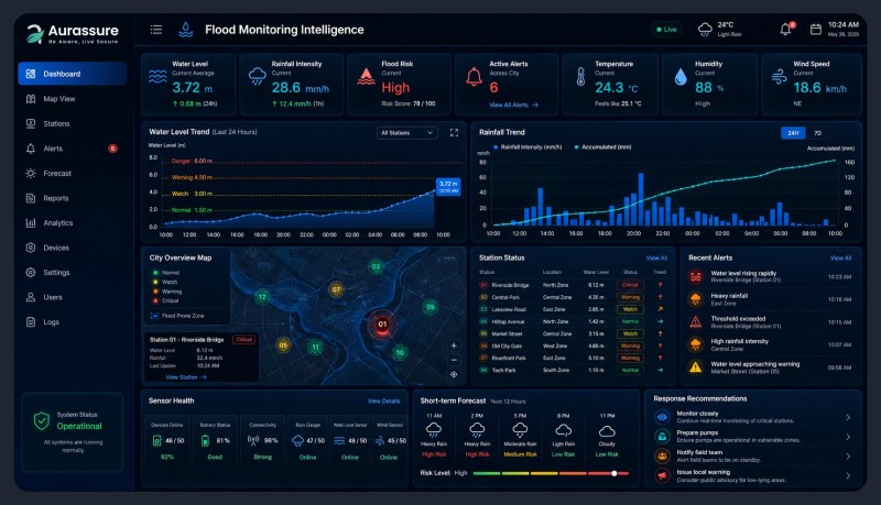
Key Flood Signals That Help Cities Respond Earlier
Aurassure Aqua tracks the most critical water, rainfall, weather, and drainage indicators needed to detect flood risk early, support warnings, and guide faster on-ground response.
Canals, Rivers, Drains, Sumps, and Inundation Points
Track rising water levels across flood-prone locations to identify overflow risk before it turns into a larger disruption.
Real-Time Rainfall and Accumulation
Measure localized rainfall intensity and accumulation to understand where drainage systems may come under pressure.
Wind, Pressure, Temperature, and Humidity
Combine weather signals with water-level and rainfall data to improve situational awareness during extreme weather events.
Pump Stations, Drainage Assets, and Warning Points
Based on deployment needs, the system can support visibility across pump houses, drainage points, underpasses, roads, and public warning locations.
One view across water, rainfall, drainage, and alerts
Instead of scattered field updates, response teams get one connected view of changing flood conditions across critical locations.
Built to Support Flood Warning and Disaster Response Readiness
Cities need more than rainfall data. They need live water-level visibility, early warnings, structured records, and faster coordination across drainage, disaster management, traffic, and command centre teams.
Real-time flood visibility
Track water levels, rainfall, drainage stress, and vulnerable locations continuously instead of relying on delayed manual updates.
Faster warnings during risk events
Use threshold-based alerts and live dashboards to notify teams early when water levels, rainfall, or inundation risk begins to rise.
Response-ready records
Maintain time-stamped data, event history, trends, and reports to support review, planning, and post-event analysis.
Better coordination across agencies
Bring flood data, warnings, and operational status into one shared view for city teams, utilities, and emergency responders.
Download Aqua Specification Sheet
Reliable Flood Data You Can Trust for Early Warning and Response
Flood monitoring data must be dependable enough to support alerts, pump station decisions, command centre visibility, and post-event review. Aurassure Aqua combines accurate sensing, configurable data transmission, and structured validation workflows to support faster and more confident action.
Aurassure Aqua supports accurate water-level monitoring across canals, rivers, sumps, drains, and inundation points, with configurable data transmission for faster flood risk visibility.
Sensor calibration and deployment checks
Water-level, rainfall, and weather sensors are configured according to site conditions, installation height, measurement range, and expected risk thresholds.
Threshold mapping for local flood risk
Each location can be mapped to warning levels based on drain capacity, canal level, sump condition, road inundation depth, and operational response needs.
Data quality for alerts and forecasting workflows
Live data is structured for dashboards, trends, alerts, forecasting workflows, and post-event analysis, helping teams improve response over time.
Supporting Flood-Resilient Cities with Real-Time Intelligence
Aurassure supports city teams, disaster management agencies, and research institutions with live flood monitoring, early warning, forecasting workflows, and decision-ready environmental data.
Chennai Smart City
Deployed flood monitoring infrastructure across canals, pathways, and sumps with water inundation level sensors and rainfall sensors to strengthen early warning and city response.
Kolkata Municipal Corporation
Flood monitoring and forecasting support for urban flood preparedness, helping city teams understand trends, forecasts, and risk conditions across vulnerable locations.
Mumbai Flood Monitoring for Climate Research
Monitoring support for flood-prone urban environments, including canals and pathways, to generate data for research, city action planning, and long-term flood resilience.
Frequently Asked Questions About Flood Monitoring and Early Warning
Get clear answers to common questions about real-time flood monitoring, water-level sensors, rainfall tracking, forecasting workflows, alerts, and city-level disaster response readiness.
What is a flood monitoring system?
A flood monitoring system uses sensors, communication networks, dashboards, and alerts to track water levels, rainfall, drainage stress, and flood-prone locations in real time. It helps cities and organizations detect rising risk early and coordinate faster response.
What parameters should be monitored for flood risk?
Key parameters include water level, rainfall, temperature, humidity, wind speed, wind direction, atmospheric pressure, and site-specific indicators such as pump station status or road inundation depth. These signals help teams understand how flood risk is evolving across critical locations.
Where can flood monitoring sensors be deployed?
Sensors can be deployed near canals, rivers, drains, underpasses, roads, low-lying neighbourhoods, sumps, pump stations, lakes, industrial premises, and other vulnerable locations where water accumulation or overflow can disrupt safety and operations.
How does an early warning system work?
Early warning works by continuously comparing live sensor data against predefined thresholds. When water levels, rainfall intensity, or other risk indicators cross warning limits, alerts can be triggered through dashboards, SMS, email, displays, or command centre workflows.
Can Aurassure support flood forecasting?
Yes. Flood forecasting can be supported through real-time sensor data, rainfall trends, weather inputs, historical records, GIS layers, and scenario-based modelling. The forecasting depth depends on the deployment scope, available data, and integration requirements of the city or organization.
Can the system monitor pump stations?
Yes. Pump station monitoring can include water level at sumps or penstocks, rainfall near pump stations, and operational status indicators depending on project requirements. This helps operators respond faster when water levels move beyond acceptable limits.
Can multiple flood-prone locations be monitored from one dashboard?
Yes. A centralized dashboard can bring multiple sensors and locations into one operational view. City teams can monitor live readings, trends, device status, alerts, historical data, and risk zones from a single platform.
What happens when water levels cross a warning threshold?
When a warning threshold is crossed, the system can trigger alerts for relevant teams with location and time details. This enables faster field action such as pump activation, road diversion, barricading, public warning, or emergency response coordination.
Can flood monitoring data be integrated with command centres?
Yes. Flood monitoring data can be integrated with city command centres, ICCC platforms, emergency response dashboards, and other operational systems through suitable APIs or data-sharing workflows.
How many flood monitoring stations does a city need?
The number of stations depends on city size, drainage network, flood history, elevation profile, critical infrastructure, vulnerable communities, and response priorities. A site assessment helps identify the right mix of water-level sensors, rainfall stations, pump station sensors, and inundation points.
Have questions about your city, campus, or infrastructure requirements?
Talk to a Flood Monitoring ExpertReady to Detect Flood Risk Before It Escalates?
See how Aurassure Aqua can help your city, campus, or infrastructure network monitor water levels, rainfall, and flood-prone locations in real time, trigger faster alerts, and support better response through one connected platform.