Powering Resilient Cities

Smart City Monitoring Solutions for Resilient Urban Operations

Connect real-time air quality, flood, weather, heat, and noise intelligence to detect risks early, coordinate faster response, and strengthen citywide decision-making.

Multi-risk intelligence
ICCC and API ready
Real-time alerts
Aurassure smart city monitoring and resilience intelligence Citywide environmental monitoring infrastructure
Live citywide environmental visibility
Connected Urban Intelligence
Air Quality · Flood · Weather · Heat · Noise
Chennai Smart City logo
Bhubaneswar Smart City logo
Agartala Smart City logo
Vadodara Smart City logo
Silvasa Smart City logo
Rajkot Smart City logo
Prayagraj Smart City logo
Pimpri Chinchwad Smart City logo
Kohima Smart City logo
Kanpur Smart City logo
Guwahati Smart City logo
Faridabad Smart City logo
Dahod Smart City logo

Get in Touch with Aurassure

SmartCity Monitoring (2) copy
Urban Reality

Cities Face Interconnected Environmental Risks Every Day

Air pollution, intense rainfall, flooding, extreme heat, noise, and changing weather conditions can vary across neighbourhoods. Without connected, real-time visibility, city response becomes slower and less coordinated.
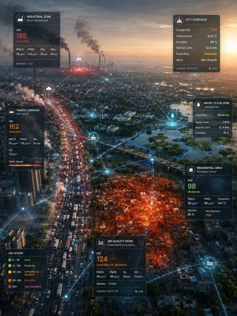
Connected environmental monitoring for smart city resilience
Urban conditions
Hyperlocal and constantly changing
Pollution hotspots
Flood-prone zones
Extreme heat
Why this matters
24×7

Urban environmental risk is continuous, interconnected, and highly local.

City teams need timely visibility across neighbourhoods and critical infrastructure to identify emerging risks, coordinate departments, and protect essential urban services.

01
Fragmented visibility
Environmental data often remains distributed across disconnected devices, departments, and systems.
02
Delayed risk detection
Without hyperlocal monitoring and alerts, emerging hotspots may be identified only after disruption begins.
03
Coordinated city response
Command centres and city departments need one shared operational view to turn monitoring into timely action.
Without Connected Monitoring

What Happens When Citywide Environmental Visibility Is Missing

When environmental conditions are monitored through fragmented systems or periodic checks, emerging risks are identified later, response becomes reactive, and disruption spreads across communities and urban services.

01

Risks Are Detected Too Late

Pollution hotspots, rising water levels, extreme heat, and severe weather may remain unnoticed until public impact or operational disruption has already begun.

02

Response Becomes Fragmented

Departments working with disconnected information may struggle to coordinate drainage, traffic, health, emergency, and field response effectively.

03

Communities and Services Face Greater Impact

Delayed intervention can increase public exposure, disrupt mobility, affect critical infrastructure, and reduce continuity of essential city services.

04

Planning Remains Reactive

Without reliable historical and hyperlocal data, cities rely on broad assumptions instead of evidence for investments, mitigation, and resilience planning.

Urban risks rarely remain isolated. A single environmental event can affect public health, mobility, infrastructure, emergency response, and citizen trust at the same time.
Core Requirements

What Climate-Ready Cities Actually Need

Managing urban environmental risk requires more than installing sensors. Cities need connected visibility, early warnings, coordinated response, and reliable intelligence that supports both daily operations and long-term resilience planning.

Connected environmental intelligence for smart city operations
01

Build Hyperlocal Citywide Visibility

Continuously monitor air quality, rainfall, water levels, weather, heat, and noise across neighbourhoods, roads, public spaces, and critical infrastructure.

02

Unify Data Across Urban Systems

Bring distributed sensor networks, maps, alerts, and historical trends into one operational view that can integrate with ICCCs, GIS platforms, and existing city systems.

03

Detect and Anticipate Risk Earlier

Use real-time thresholds, predictive analytics, forecasts, and automated warnings to identify pollution hotspots, flooding, severe weather, and heat-related risks before they escalate.

04

Coordinate Response and Resilience Planning

Equip command centres and departments with shared intelligence for faster field action, stronger public communication, evidence-based investment, and long-term climate resilience.

Connected City Intelligence

See How Environmental Data Becomes Coordinated City Action

Aurassure connects distributed environmental monitoring networks with dashboards, predictive insights, automated alerts, and command-centre integrations—giving city teams one operational view of changing urban conditions.

01

Monitor Conditions Across the City

Capture hyperlocal air quality, rainfall, water level, weather, heat, and noise data across neighbourhoods and critical locations.

02

Identify Emerging Risks Earlier

Detect pollution hotspots, flood risk, extreme weather, and heat stress through thresholds, forecasts, trends, and automated alerts.

03

Coordinate Response Through One View

Share actionable intelligence with ICCCs, municipal departments, field teams, and decision-makers for faster, coordinated response.

Live urban intelligence
From sensing to response
Monitor · Analyse · Alert · Coordinate
01
Citywide Networks

Distributed monitoring across critical urban locations.

02
Predictive Intelligence

Forecasts, risk signals, and automated early warnings.

03
ICCC Integration

Connected data for command centres and city systems.

Download
Aurassure Brochure

Get in Touch with Aurassure

Connected Solution Architecture

From Distributed City Sensors to Coordinated Urban Action

Aurassure connects environmental monitoring networks, predictive intelligence, and city systems through one integrated framework—helping authorities move from fragmented data to faster, evidence-based action.

01
Sensing Layer

Monitor the City at Street Level

Deploy connected monitoring infrastructure across neighbourhoods, roads, public spaces, waterways, and critical urban assets.

Air quality Rainfall Water levels Weather Heat Noise
02
Intelligence Layer

Understand What the Data Means

Combine live measurements, historical trends, forecasts, thresholds, and predictive models to identify emerging urban risks.

Hotspot detection Risk forecasting Trend analysis Automated alerts Spatial intelligence
03
Action Layer

Connect Intelligence with City Operations

Deliver actionable information to command centres, municipal departments, field teams, public platforms, and decision-makers.

ICCC integration GIS and APIs SMS and email alerts Public displays Operational reports
Integrated Monitoring Ecosystem

One Platform. Multiple Urban Use Cases.

Cities can begin with one priority risk and progressively build a connected environmental intelligence network across departments.

AQ

Air Quality Intelligence

Track particulate matter, gases, pollution hotspots, and neighbourhood-level exposure.

FL

Flood and Water-Level Intelligence

Monitor rainfall, drains, rivers, underpasses, and vulnerable urban locations.

WX

Hyperlocal Weather Intelligence

Measure rainfall, wind, temperature, humidity, pressure, and severe weather conditions.

CR

Heat and Climate Risk

Identify heat-risk zones, changing microclimates, and patterns affecting vulnerable communities.

NS

Urban Noise Monitoring

Understand noise conditions near traffic corridors, public spaces, institutions, and sensitive zones.

IN

Unified Intelligence Platform

Bring maps, dashboards, alerts, reports, forecasts, and system integrations into one operational environment.

Designed around your city’s priorities

Build a monitoring network that scales across risks and departments.

Discuss Your City Requirements
Dashboard and ICCC Integration

One Operational View of the Entire City

Aurassure brings live environmental conditions, geographic risk, device status, forecasts, alerts, and historical trends into one connected interface for command centres and municipal teams.

Intelligence Layers
System Status Network operational
Live City Environment Unified Monitoring Overview
Live data
Aurassure unified city monitoring dashboard
Operational Access

Intelligence Where Each City Stakeholder Needs It

Provide relevant environmental information to command centres, departments, field teams, and public-facing platforms.

01

ICCC and Control Rooms

Unified maps, alerts, risk status, and citywide device visibility for central operations.

02

Department Dashboards

Role-based access for environment, drainage, disaster management, health, and engineering teams.

03

Mobile and Field Access

Live conditions, location-specific alerts, and device information for field response teams.

04

Public Information Systems

Share selected air quality, weather, flood, and advisory information through public channels.

Open Integration Framework

Connect With Existing City Technology Infrastructure

ICCC GIS SCADA APIs Mobile Apps Public Displays Emergency Systems
From Intelligence to Action

Turn Environmental Signals Into Coordinated City Decisions

Smart city monitoring creates greater value when environmental signals move quickly from detection to departmental action. Aurassure helps cities establish a continuous response loop across command centres, field teams, and decision-makers.

Connected Intelligence City Action Loop

Real-time data, forecasts, alerts, and operational context

Continuously updated
01

Detect

Identify changing conditions across monitored locations.

02

Prioritise

Assess severity, location, trend, and likely impact.

03

Coordinate

Share actionable intelligence with relevant departments.

04

Improve

Review events and strengthen future city response.

What this enables

Faster action across everyday operations and urban emergencies

City teams can use live and predictive intelligence to initiate location-specific actions instead of relying on delayed reports or citywide assumptions.

AQ

Respond to Pollution Hotspots

Identify affected areas, understand pollutant trends, and support targeted traffic, enforcement, or public-health action.

FL

Act on Rising Flood Risk

Trigger drainage checks, pump activation, road closures, field verification, and public advisories using rainfall and water-level intelligence.

HT

Protect Heat-Vulnerable Areas

Identify high-risk locations and support targeted advisories, cooling interventions, and public-health preparedness.

WX

Prepare for Severe Weather

Use hyperlocal forecasts and alerts to prepare departments, protect assets, and maintain continuity of essential services.

Example Response Journey

Rising water level at an urban underpass

01
Sensor detects rise

Water level crosses a configured early-warning threshold.

02
Risk is validated

Rainfall, trend, location, and forecast data provide context.

03
Teams are alerted

ICCC, drainage, traffic, and field teams receive the event.

04
Action is coordinated

Pumps, diversions, field checks, and public advisories are initiated.

The objective is not only to see what is happening across the city. It is to help the right teams act before environmental risk becomes widespread disruption.
Data Quality and Reliability

City Decisions Need Environmental Data They Can Trust

Smart city monitoring networks operate continuously across varied neighbourhoods, weather conditions, and infrastructure environments. Aurassure combines calibration, automated quality checks, device-health monitoring, and structured maintenance to sustain dependable citywide intelligence.

01
Before Deployment

Validate Every Monitoring Asset

Factory calibration and sensor verification
Reference-aligned and co-location testing
Site-specific configuration and threshold setup
Connectivity, power, and enclosure checks
03
For Decision Use

Preserve Context and Traceability

Time-stamped historical environmental records
Location and device-level data traceability
Structured reports and event documentation
Consistent data access across integrated systems
Network Assurance

Reliability Is Managed Across the Complete Monitoring Lifecycle

A dependable city network requires more than accurate sensors. It requires visibility into data quality, device performance, connectivity, maintenance, and the operational history behind every environmental reading.

01
Sensor Performance

Calibration and measurement consistency

Quality managed
02
Data Continuity

Transmission, gaps, and anomaly visibility

Continuously checked
03
Device Health

Power, connectivity, and operational status

Remotely monitored
04
Service Readiness

Maintenance and field-support workflows

Lifecycle supported
Built for long-term urban deployments From individual monitoring stations to distributed city networks, every layer is designed to support dependable environmental intelligence.
Calibration Automated QA/QC Remote Diagnostics Preventive Maintenance Audit Trails
Citizen Awareness

Make Environmental Intelligence Visible Across the City

Share selected air quality, weather, flood, heat, and advisory information through public displays, kiosks, city portals, and mobile-friendly platforms.

Smart city public environmental information display
Live environmental information
Public Information Layer

Turn complex environmental data into clear public information

Citizen-facing information helps communities understand local conditions, prepare for emerging risks, and make informed daily decisions.

01

Improve Public Awareness

Share understandable environmental conditions at public and high-footfall locations.

02

Deliver Local Advisories

Communicate guidance based on neighbourhood-level conditions and emerging risks.

03

Strengthen Transparency

Make monitoring initiatives visible and show how environmental data supports city decisions.

01

Outdoor Displays

Show live conditions at public spaces, intersections, institutions, and transport hubs.

02

Interactive Kiosks

Provide local conditions, historical trends, public advisories, and awareness content.

03

Mobile and Web

Share dashboards, forecasts, alerts, and advisories through city portals and applications.

From monitoring to public awareness Turn city environmental data into clear, accessible public information.
Explore Public Information Solutions
Flexible Deployment

Start With a Priority Risk. Scale Across the City.

Begin with high-risk locations or a priority use case, then expand the monitoring network across risks, departments, and city systems.

01
Assess

Identify Risks and Priority Locations

Assess vulnerable zones, existing systems, data gaps, and the operational decisions the network must support.

02
Deploy

Begin With High-Impact Zones

Start with selected pollution hotspots, flood-prone areas, transport corridors, or critical infrastructure.

03
Integrate

Connect With Existing City Systems

Integrate dashboards, alerts, maps, APIs, GIS platforms, ICCCs, and departmental workflows.

04
Scale

Expand Across Risks and Departments

Add new locations, environmental parameters, public information channels, and resilience use cases.

01 Flexible Power
02 Multiple Connectivity Options
03 Outdoor-Ready Systems
04 Lifecycle Support
Plan Your Deployment Define the right monitoring architecture for your city’s risks, infrastructure, and operational priorities.
Discuss a City Deployment
Proven Urban Deployments

Environmental Intelligence Built for Real Cities

From citywide air-quality networks to flood early-warning systems, Aurassure has supported municipal authorities, Smart City SPVs, system integrators, and development partners across varied urban environments.

Rajkot Smart City environmental monitoring network
Rajkot, India 20 IoT Sensors
Air Quality and Environment

Environmental Monitoring Integrated With Smart-City Infrastructure

Sensors installed across smart poles delivered real-time air quality, weather, and noise intelligence through centralized dashboards and public information systems.

Air quality Weather Noise monitoring Public information
Explore Deployment
Bhubaneswar Smart City environmental monitoring network
Bhubaneswar, India 10 Stations + 2 Displays
Pan-City Environment Network

Connected Environmental Visibility for Bhubaneswar Smart City

Ten environmental stations and two digital displays supported real-time air-quality, weather, and noise visibility for administrators and citizens.

ICCC integration Public displays Automated reports
Explore Deployment
Build on proven deployment experience Design a smart city monitoring network around your local risks, infrastructure, and operational priorities.
Discuss Your City Project
Why Aurassure

Built to Support City-Scale Environmental Intelligence

Aurassure combines connected monitoring, predictive intelligence, system integration, and lifecycle support to help cities build dependable environmental intelligence networks.

10Bn+ Environmental data points
3K+ Devices deployed
10+ Countries
01

Multi-Risk Intelligence

Monitor air quality, rainfall, water levels, weather, heat, noise, and customised environmental parameters through one connected ecosystem.

02

Predictive and Actionable

Combine real-time data with dashboards, alerts, forecasts, models, and risk intelligence to support proactive city decisions.

03

Integration Ready

Connect environmental data with ICCCs, GIS platforms, public portals, mobile applications, and departmental systems through APIs.

04

End-to-End Support

Support network planning, installation, calibration, configuration, training, maintenance, remote diagnostics, and long-term operations.

Built around your city’s priorities Create a scalable monitoring network across risks, locations, and departments.
Talk to Our Smart Cities Team
Smart City Monitoring FAQs

Common Questions About Building a Citywide Monitoring Network

Explore how Aurassure supports municipalities, Smart City SPVs, development authorities, and system integrators across monitoring, integration, deployment, data management, and long-term operations.

01 What is Smart City Monitoring?
Smart City Monitoring uses connected sensors, communication networks, dashboards, analytics, and alerts to continuously track urban conditions. For environmental applications, this can include air quality, rainfall, water levels, weather, heat, and noise across neighbourhoods and critical infrastructure.
02 What environmental parameters can Aurassure monitor across a city?
Aurassure can monitor particulate matter, gaseous pollutants, rainfall, water levels, wind, temperature, humidity, atmospheric pressure, solar radiation, heat indicators, and noise. The exact configuration can be adapted to the city’s risks, locations, and programme objectives.
03 Can the platform integrate with an existing ICCC?
Yes. Environmental data, alerts, device status, maps, and reports can be integrated with Integrated Command and Control Centres through APIs and project-specific interfaces. Integration can also extend to GIS, SCADA, public portals, mobile applications, and departmental systems.
04 Can Aurassure work with sensors already deployed by the city?
Existing monitoring assets may be integrated when their protocols, data formats, access permissions, and technical compatibility allow it. Aurassure can also fill geographic or parameter gaps without requiring the city to replace its complete monitoring network.
05 Does a city need to deploy the complete network at once?
No. Cities can begin with a priority-zone pilot, a single-risk network, or selected critical locations. The network can then expand across additional zones, environmental parameters, departments, and public-information channels.
06 How are monitoring locations selected?
Site selection considers the city’s risk profile, population exposure, drainage and flood history, traffic patterns, land use, critical infrastructure, data gaps, communication availability, and the operational decisions the network must support.
07 How do automated alerts support city response?
Alerts can be configured around thresholds, trends, forecasts, and location-specific risk conditions. Notifications can support command centres, municipal departments, field teams, and other authorised stakeholders through dashboards, email, SMS, or project-defined channels.
08 How is data quality maintained across a distributed network?
Data quality is supported through calibration, validation, automated anomaly detection, device-health monitoring, remote diagnostics, maintenance workflows, and traceable historical records. The exact quality-assurance programme depends on the monitoring scope and contractual requirements.
09 What power and connectivity options are available?
Depending on the device and project requirements, deployments can use AC, DC, solar, and battery-supported power configurations. Connectivity can include cellular, Wi-Fi, Ethernet, LoRa, and other suitable communication options.
10 Can environmental information be shared with citizens?
Yes. Selected air-quality, weather, flood, heat, and advisory information can be shared through outdoor displays, kiosks, public portals, mobile-friendly dashboards, and city applications. Public information can be configured separately from internal operational access.
Build a Climate-Ready City

Turn Citywide Environmental Data Into Faster, Smarter Action

Connect air quality, flood, weather, heat, and noise monitoring with real-time dashboards, automated alerts, predictive intelligence, and existing city systems.

Air Quality Flood Monitoring Weather Intelligence Heat Risk Noise Monitoring ICCC Integration
icon

We have received your message and will get back to you as soon as possible.

If you need immediate assistance,

please feel free to give us a call at +91 907 8035 811.

Ensure Regulatory Compliance​

Thank You!

Explore more insights and resources

on our website.

Download
Aurassure Brochure

By submitting this form, you consent to receive communications from us, including newsletters, product updates, and relevant insights. You can unsubscribe at any time.

Indoor Air Quality Management System

Download Our Brochure Now

Get detailed insights into how Aurassure IAQMS improves air quality, reduces energy costs, and ensures compliance.

icon

We appreciate your feedback and will use it to improve our products and services. 

If you have any immediate concerns, 

please contact our customer success team (+91 90780 32911).

Contact Aurassure

Fill out the form below, and we will be in touch shortly.
Details Regarding